Cloghleagh Mine, 1862-1868
I am a believer in “giving it a go”, at least once anyway. So without a cave to survey we found the next best thing. I had known of the Cloghleagh Mine for several years now, but have never really had the chance to explore it. So a few weekends ago, myself and Erin decided to head up and have a look in, we armed ourselves with two helmets, two iPhone compasses, and a 10’ measuring tape.
The mine site is quite obvious when you pass by on the walking trail, with a large open area (Dressing Floor) once used for ore processing, the clear cut in the hill above where surface mining had once been attempted and of course the portal in the side of the rock face. Other than that I don’t know much about this particular mine, and I cannot find much online either, with the notable exceptions of the mine’s entry on mindat.org (see below) and a GSI Site Report1.
According to the Site Report, there, until recently, was an original Victorian mine building (derelict but standing) on the site, said to be built by the Rev. William Ogle Moore. The land up above the portal, the surface workings, is littered with loose lumps of quartz and what I’m calling “Red Granite”. The site has also been adopted by dirt bikers, who have really done damage to the site. The report also mentions a relationship between the Cloghleagh Mine site and the Deerpark Cave near Powerscourt, Co. Wicklow. A pseudokarstic cave formed within a ferruginous conglomerate, located near the footwall of the Bray Thrust fault2.
But enough of that and back to our little adventure. We I had it in my head that the mine would by relatively dry inside, since it hadn’t been carved by a stream of water but rather by the stream of sweat off the brow of a few hardy men doing a day’s work. Oh how was I wrong…the mine was flooded from just inside the entrance portal. We 8 survey stations, and found 2 terminating “passages”. I say that because I don’t think either was long enough to really be classed as passages.
Sadly the mine has been used for dumping of what mainly appears to be left overs from barbecues or camping trips, it is at least some consolation that it appears to only have affected a single passage, the aptly named “Duvet Dump Passage”. Water levels at the furthest east station, were at wellie height. This ultimately lead to the abandonment of the surveying efforts for that day. When discussing waiting for drier weather, one caver said to me “Or you could just wear your caving gear”.
This is of course what we probably should have done initially. We peered as far as we could into the passage, we know the passage continues around the corner beyond the final station, but as to how far it could be anyones guess.
When we began to process our data we discovered the magnitude of the issue with using compasses in an iron mine…lots and lots of deviations between front and back sights. Awh well it’s something to improve upon. I can’t wait to return and retake the survey data with better equipment and ultimately see what’s around the next corner.
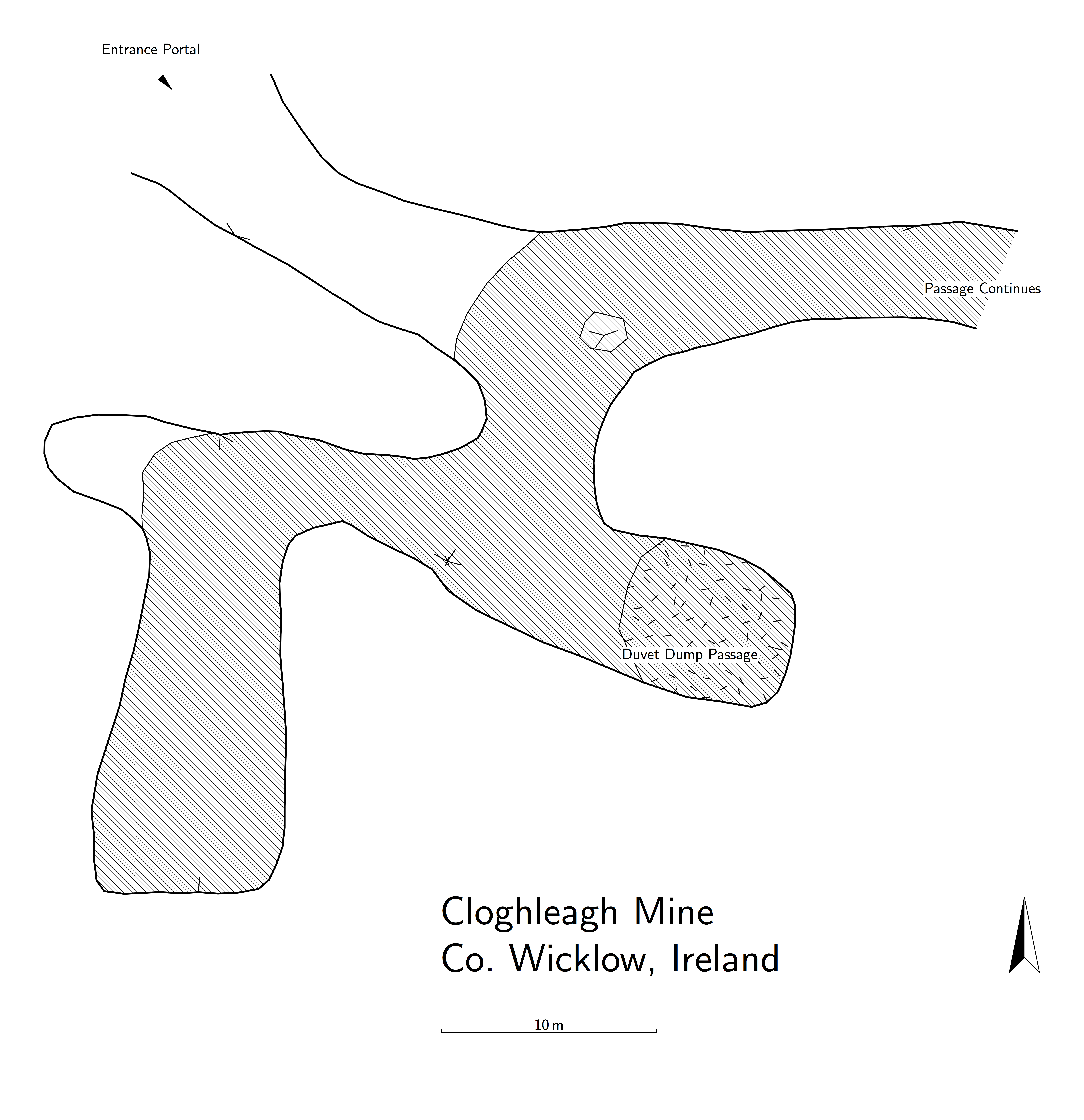
Our survey of the mine.
Links
-
Meehan, R., Parkes, M., Gallagher, V., Hennessy, R. and Gatley, S. 2014. The Geological Heritage of Wicklow. An Audit of County Geological Sites in Wicklow. Geological Survey of Ireland. Unpublished Report. https://secure.dccae.gov.ie/GSI_DOWNLOAD/Geoheritage/Reports/WW016_Cloghleagh_Mine.pdf ↩︎
-
Jordan, D.B., Jones, G.L., 2005, The Powerscourt Conglomerate and its Bearing on Neotectonic Activity in Central East Ireland. Irish Journal of Earth Sciences 23, 47-54 ↩︎